
The EMu ArcExplorer report takes EMu records with location (latitude / longitude) information and displays them on maps in the third party application, ArcExplorer:
ArcExplorer is a freely available lightweight GIS data viewer that lets you perform a variety of basic GIS functions. With ArcExplorer, it is possible to:
- Display and query a variety of standard data sources, including:
- ESRI shapefiles
- ArcInfo coverages
- Images
- ArcIMS services
- Pan and zoom through multiple layers and identify, locate, and query geographic and attribute data.
- Symboli
- Perform basic spatial analysis tasks on the geographic data, such as selecting and buffering features.
In order to run the ArcExplorer report:
- You must be using an EMu client built after March 2010.
- Two ArcExplorer Registry entries must be specified in the EMu Registry.
-
ArcExplorer must be installed on your computer
In order to run ArcExplorer reports in EMu it is necessary that the ESRI ArcExplorer application is installed on your computer. The application can be freely downloaded from http://www.esri.com/software/arcexplorer/download.html (it is necessary to register with ESRI in order to download the installation file).
Note: The ArcExplorer report does not work with ArcExplorer 9.3.1, so be sure to download ArcExplorer 2.3.2 (Java Edition for Education) or later.
Installation instructions and System Requirements are provided by ESRI (although it is a fairly straightforward installation).
Information on the usage and licensing of ArcExplorer can be found at http://www.esri.com/software/arcexplorer/common-questions.html and in the PDF installed along with the application.
Running an ArcExplorer report is similar to running any other report in EMu:
- Search for or retrieve a group of records in a module.
- Click Reports

The Reports box displays with a list of pre-defined reports. The list includes the report name, its Type and the name of the owner of the report (who created it).
- Select a report of Type ArcExplorer.
- Click Report to generate the report using the currentThe record currently displayed in Details View or highlighted in List View (there is a faint dotted line around it). It is only possible to have one current record at a time. record or selectedA selected record is one that has been chosen either on its own or to as part of a group of records. It is usual to select the records you want to be affected by an operation before performing the operation. Selected records are used in many instances, e.g. when a number of records are to be: discarded, saved in a group, or attached to another record. A selected record displays on screen with a blue background when in List View. records
-OR-
Click Report All to generate the report using all listed records.
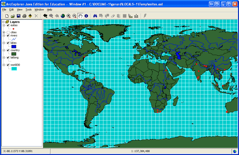
The ArcExplorer application will open with the data mapped:
With the data displayed in ArcExplorer, it can now be manipulated using the many tools available in the application.